
40 Cool Maps That Reveal Surprising Facts About the World
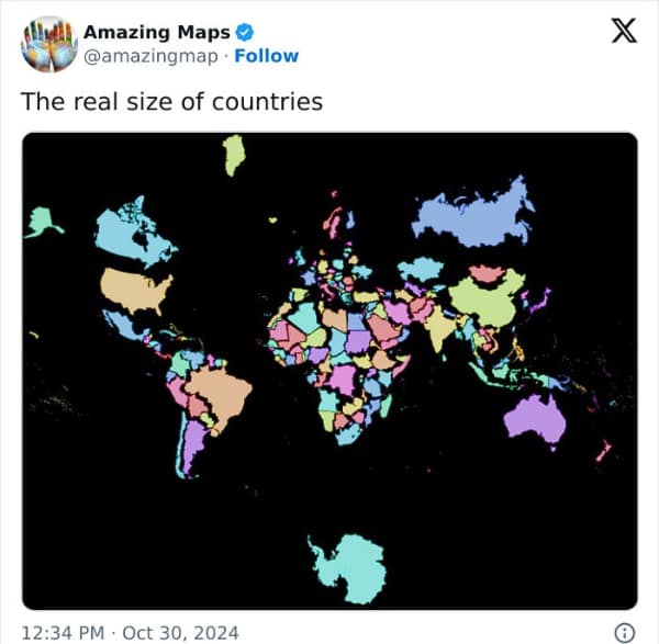
Maps—the unsung heroes of the educational world. I remember the first time I saw a map that made me stop and think, "Wait, is that really how it looks?" It was a map showing the true size of Africa compared to other continents, and it completely blew my mind. From that moment, I knew that maps were more than just tools for navigation—they were windows into the world’s most fascinating secrets. And so, I set out to gather 40 of the most interesting maps and cool maps that will make you rethink everything you thought you knew about geography.
This collection of 40 interesting maps is a journey through the world’s most fascinating geographical quirks. Each map is a snapshot of a moment where the world reveals something unexpected, from the true size of countries to the distribution of languages and cultures. The photos are a mix of historical maps, modern data visualizations, and even some quirky interpretations of the world, with each one offering a glimpse into the complexity of our planet. Whether it’s cool maps showing the most popular pizza toppings by country or a visualization of the world’s time zones, these interesting maps are a reminder that sometimes, the best way to understand the world is to look at it from a different perspective.


You just scrolled through 40 interesting maps that made you rethink everything you thought you knew about geography. Hopefully as you leave you are sharing your favorites with friends, knowing that they would appreciate the unique blend of education and entertainment that only interesting maps can provide.
If you enjoyed this dive into the world of interesting maps, check out our collection of historical memes or our gallery of quirky data visualizations. Our site is filled with the same kind of humor and insight that makes you laugh and learn in equal measure.
Read Memes
Get Paid

Phil M., Co‑Founder & Content Strategist
Phil is one of Thunder Dungeon’s co‑founders, doubling as our resident meme analyst and dark‑room brainstormer. He specializes in trend‑spotting across social platforms and shapes the editorial calendar to keep our galleries fresh, topical, and worthy of your valuable procrastination.


I found the political partisanship completely annoying. This is obviously on the part of certian creators. There’s a time and a place, you know?